Drillian - Geography & Ecology
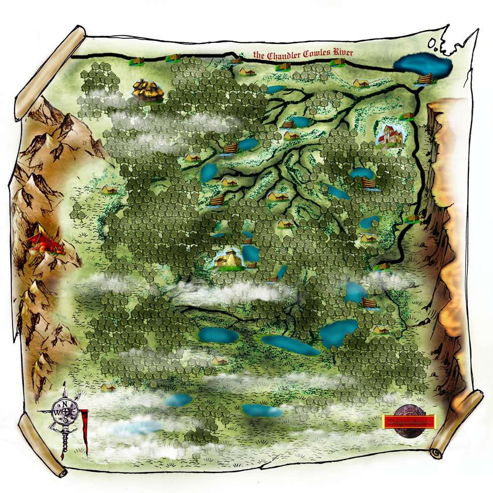
Drillian as part of the Small Kingdoms is bounded on two sides by swampy areas and water on a third side or as some say Drillian is two hills in the swamp. Drillian is located to the west of Rivers Bend and shares a 'border' with Carnak along the southern portion of the Central Mountains. The Chandler Cowles River flows from west to east forming the northern border of the Kingdom and then where it turns south and creates the ribbon delta along the eastern border of Drillian. This is where the Baikal River flows out of Lake Peipus and down through a maze of channels and marshes until it reaches the Great Swamp. With the large escarpment that forms the great plateau forcing waters south and west the Baikal is often a starting point to get to the central reaches of Drillian. Many of the channels coming off the Baikal, such as the Crystal River and the Queens Channel have had some dredging work done on them to help with navigation. The Great Swamp forms the southern edge of Drillian but the issues created by the Mist and the terrain present problems identifying a definitive border. The central part of the Kingdom is mostly marsh area with hills to the northeast and along the western border.
The western border between Drillian and Carnak is more of a theoretical line that the tribes in Carnak respect that lies somewhere in the hills between the two Countries. The fact that there are several dragon lairs in the hills also contributes to Drillian not claiming any significant areas in the hills.
The silt from the Chandler Cowles River provides a very rich soil from periodic flooding of the river. Most of the local populace in Drillian has some passing skill at using a boat or even knows how to swim. In the Northeast corner of the country lies the small town of Roppenmere. The hamlet of Midturn lies along the banks of the Chandler Cowles River in the Northwestern corner of Drillian. The Jistille Estates lie in the north central area of Drillian.
There are several stretches of large berms or dikes scattered throughout Drillian that are parts of various attempts to drain the land or provide protection from the various floods that happen periodically. The Cowles Estates is in the center of an extensive reclamation project to convert the swamps into arable land. There is network of small canals dug to circulate the water away and around fields for crops and other uses. The Vilmar Estates are in the center of another smaller version of this type of project.
One quirk of Drillian's geography is that there are several large lighthouses built here to help guide travelers through the maze of channels and swamps. The richer estates each have their own lighthouse to guide travelers and help to find their way through the Mist as well.

Players Map of Drillian.
